CURRENT SITUATION
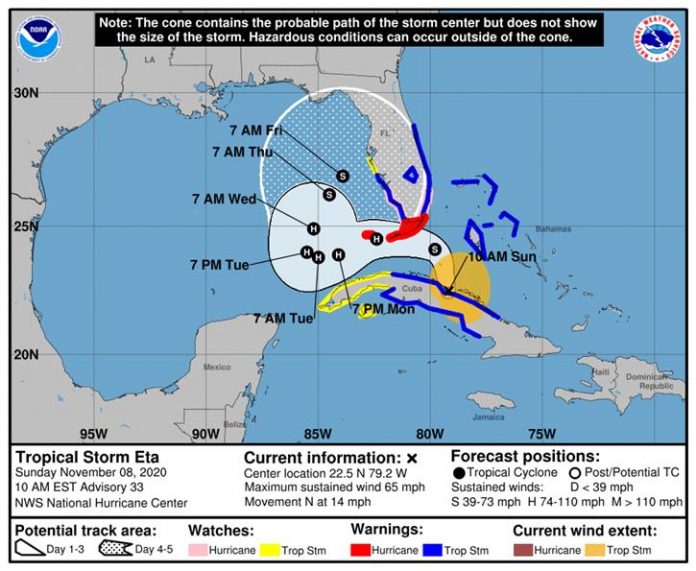
The center of Eta is located about 235 miles south-southeast of Miami, FL, moving north at 14 mph. Maximum sustained winds are near 65 mph, and additional strengthening is expected through Sunday night. Eta is now forecast to be a hurricane as it passes near and over the Keys and into the southern Gulf of Mexico.
Eta will move over or near the Keys tonight and into the southeastern Gulf of Mexico on Monday. Eta will turn northward over the eastern Gulf of Mexico Monday into Tuesday, then turn northeastward later in the week. Strong winds, heavy rainfall, and dangerous marine conditions are possible for our area. Coastal flooding is also possible later in the week as moves slowly off our coast Wednesday through Friday. Most guidance suggests Eta will come back slowly to the north during second half of work week, however details of how close to the west coast and its intensity are still of low confidence.
Wind: As of the current forecast, Hernando County has a 10 to 20% chance of receiving tropical storm force winds (sustained winds greater than 39 mph). The forecasted time of arrival is 4:00 a.m. to 8:00 p.m. on Monday.
Surge: Monday night tides are forecasted to be 1 to 2 feet below normal due to offshore wind flow. Tuesday through Friday, if Eta tracks closer to the coast, we could see 3 to 5 feet above ground level (mean high high water). If it tracks further from the coast, expect 2 to 3 feet above normal tides (mean high high water).
Rain: Just over an inch of rain is forecast for our area through Wednesday. However, any changes in the forecast track is likely to also change the rainfall forecast.
Residents are encouraged to be mindful that this is likely to be a long duration event, and there remains a high degree of uncertainty in the track, magnitude, and timing of this system. It is important that residents monitor the progress of this system over the next several days. Residents are also encouraged to refresh their emergency supply kits and ensure that their disaster plan is in place.
RECOMMENDED ACTIONS
• Register for automated severe weather notifications at http://www.AlertHernando.org
• Take this opportunity to refresh your emergency supply kit. For more information, visit http://www.HernandoCounty.us/EM
• Residents are encouraged to monitor local media outlets or the National Weather Service at https://www.weather.gov/tbw/ for current weather information.
• Test your weather radio today and change the battery if needed.

