Aug. 29, 2019 CURRENT SITUATION
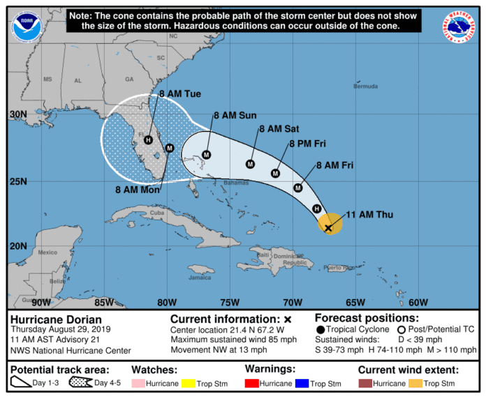
Hurricane Dorian is forecast to be a Major Category 4 (or higher) Hurricane with winds over 130 mph as it approaches the east coast of Florida on Sunday. Expect strong tropical storm or hurricane force winds to affect Hernando County as early as Sunday.
Potential storm surge 3 to 6 feet above high tide may occur anytime between Monday and Wednesday. Heavy rainfall of 4 to 8 inches (12 inches isolated) is forecast across the Florida Peninsula Friday through Sunday. Saturated ground and heavy rain may lead to significant overland and river flooding later Sunday and next week with the possibility of rivers rising to flood stage. Dangerous marine conditions and a high risk of rip currents are expected for next week, even after the storm moves out of the area. There are no watches or warnings in effect at this time. Hernando County Emergency Management is continuously monitoring and evaluating the progress of Dorian. More information for Hernando County residents will be released as it becomes available.
Damaging winds, flash flooding, river flooding, storm surge and isolated tornadoes are all possible this weekend statewide. Confidence has increased in the intensity forecast this weekend, but the exact track remains uncertain. All locations in Florida should continue to monitor Dorian for possible impacts over the Labor Day Weekend.
RECOMMENDED ACTIONS
Residents should review emergency plans and refresh emergency supply kits. For more information, visit http://www.HernandoCounty.us/EM
Residents living in low lying, flood prone areas are urged to closely monitor and take precautions as needed to protect life and property. Be prepared to evacuate to higher ground if necessary.
Do not drive through standing water. Turn around, don’t drown.
Mariners should note the potential for hazardous boating conditions in the Gulf of Mexico next week and monitor alerts from the National Weather Service.
Monitor river gauges at http://water.weather.gov/ahps2/index.php?wfo=tbw
PUBLIC INFORMATION CENTER (PIC): (352) 754-4083 or (352) 754-4111 (Recorded)

